000
AXNT20 KNHC 150441
TWDAT
Tropical Weather Discussion
NWS National Hurricane Center Miami FL
0605 UTC Wed May 15 2024
Tropical Weather Discussion for North America, Central America
Gulf of Mexico, Caribbean Sea, northern sections of South
America, and Atlantic Ocean to the African coast from the
Equator to 31N. The following information is based on satellite
imagery, weather observations, radar and meteorological analysis.
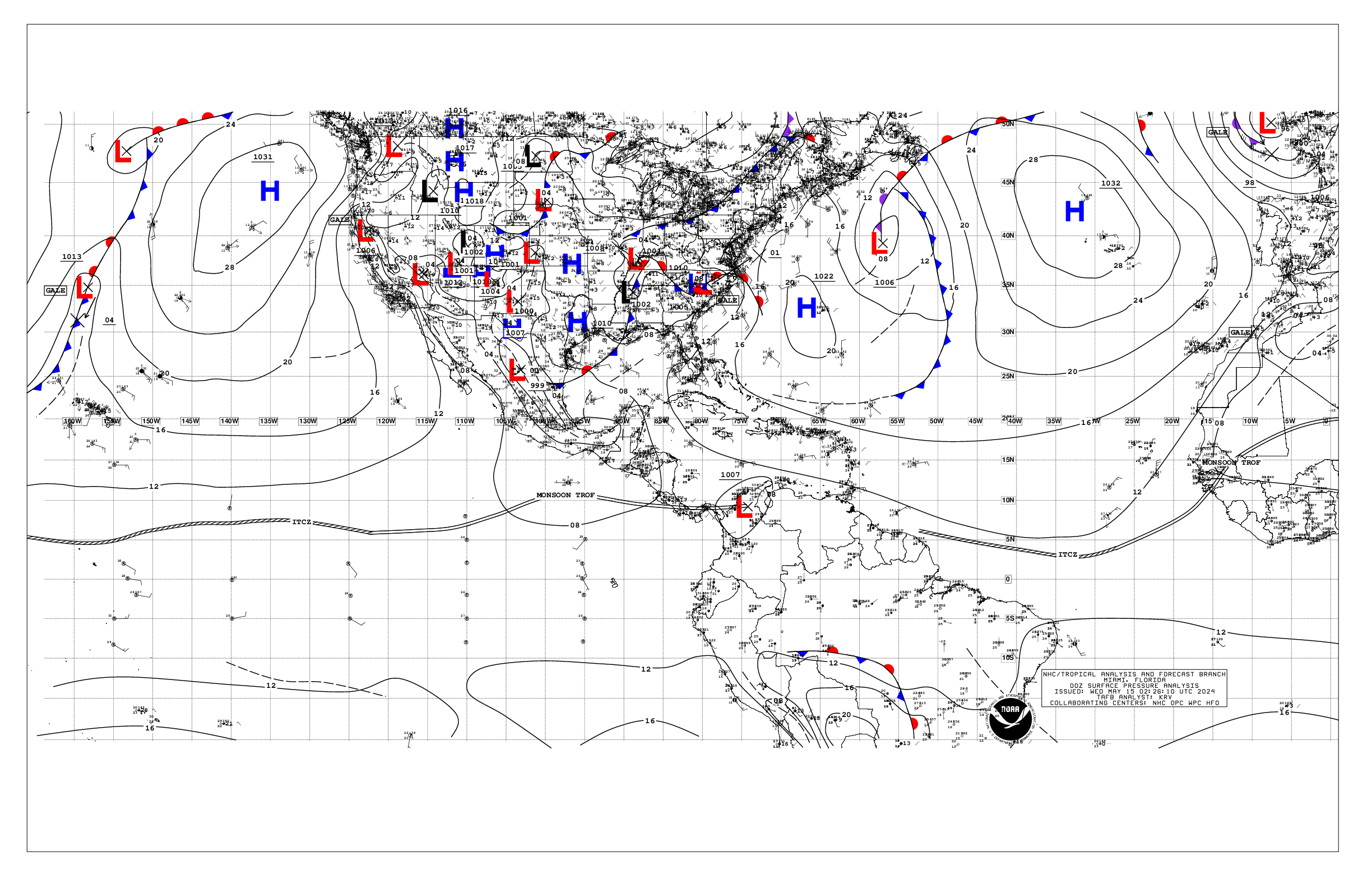
Based on 0000 UTC surface analysis and satellite imagery through
0437 UTC.
...SPECIAL FEATURES...
Eastern Atlantic Ocean Gale Warning: Pulsing gale-force winds are
forecast in the Agadir area of the Meteo-France high seas
forecast, specifically through 15/03 UTC, then again from 15/12
UTC to 16/00 UTC. Seas of 8-10 ft are possible with these winds.
Please read the latest High Seas Forecast is issued by Meteo-
France at https://wwmiws.wmo.int for more details.
...MONSOON TROUGH/ITCZ...
The monsoon trough passes through the coastal plains of Guinea-
Bissau near 11N15W to 04N27W. The ITCZ continues from 04N27W to
04N43W to 06N52W. Scattered moderate to isolated strong
convection is noted from the Equator to 06N between 21W and 36W,
and from 05N to 09N between 43W and 51W.
...GULF OF MEXICO...
A cold front over the NW Gulf extends from SE Louisiana to
26N93W then becomes stationary to just S of the Rio Grande.
Ahead of the front, a line of moderate to strong convection is
moving ESE through portions of the central Gulf from 24N to 27N
between 86.5W to 92W in association to a surface trough. Another
surface trough is depicted over the Yucatan Peninsula and it is
producing moderate to strong convection over the eastern Bay of
Campeche. Moderate to fresh return flow is east of front, with
gentle to moderate NE winds west of the front. Seas are in the 4-
6 ft range east of the front, and in the 3-5 ft range west of
the front.
For the forecast, a stationary front extends over the NW Gulf
from central Louisiana to south of the Rio Grande. Ahead of the
front, thunderstorms are moving through portions of the central
Gulf. These thunderstorms could have locally stronger winds,
rougher seas, frequent lightning and heavy rain. Thunderstorms
could continue through Wed along the stationary front.
Elsewhere, moderate to fresh return flow will dominate the
basin, pulsing to locally strong near the Yucatan Peninsula and
Yucatan Channel. Winds may slightly weaken during the upcoming
weekend as the gradient relaxes. Meanwhile, haze due to
agricultural fires in Mexico continues across most of the
western Gulf and Bay of Campeche.
...CARIBBEAN SEA...
A relatively tight pressure gradient is across the basin, with
fresh to strong winds in the NW Caribbean W of 84.5W, and in the
central Caribbean. Moderate to fresh E-SE winds are elsewhere.
Seas are in the 5-7 ft range in the NW Caribbean W of 84.5W, in
the 6-9 ft range in the central Caribbean, and in the 2-5 ft
range elsewhere. Deep convection is noted in the SW Caribbean S
of 11N near the monsoon trough.
For the forecast, high pressure centered over the central
Atlantic will support strong to near gale E to SE winds near the
Gulf of Honduras and fresh to strong winds in the south-central
basin through Sat night. Moderate to rough seas are expected
with the increasing winds. Gentle to moderate winds are expected
elsewhere through most of the week. Meanwhile, haze due to
agricultural fires in Central America continues across some
areas of the northwestern Caribbean.
...ATLANTIC OCEAN...
Please refer to the Special Features section for details on a
Gale Warning in the East Atlantic Ocean.
A weak cold front extends from 31N48.5W to 23.5N53W, then it is
dissipating to near 22N57W. A surface trough follows the front
from 22N57 to N of the Turks and Caicos. Moderate southerly
winds and seas in the 5-7 ft range are N of 29N between the
front and 45.5W. High pressure of 1022 mb is centered W of
Bermuda near 33N66W and is building in behind the front. Fresh
to strong southerly winds and seas in the 5-8 ft range are noted
off the NE Florida coast due to another approaching cold front.
Gentle to moderate winds and seas in the 3-6 ft range are
elsewhere west of the front. To the east of the front, high
pressure dominates the waters. Gentle to moderate trades prevail
across the open waters along with seas in the 4-7 ft seas,
except fresh to strong winds N of 18N between the coast of
Africa and 21W.
For the forecast, fresh to locally strong southerly winds and
seas of 5 to 8 ft are noted off the NE Florida coast due to an
approaching cold front. As the front moves off the Florida coast
Thu, these fresh to strong winds will spread E as the front
continues moving eastward. Showers and thunderstorms are also
possible along the front. By Fri night, the front will stall and
weaken from near Bermuda to the central Bahamas. Conditions
around the front should improve by Fri, with tranquil conditions
then continuing through the upcoming weekend.
$$
KRV


