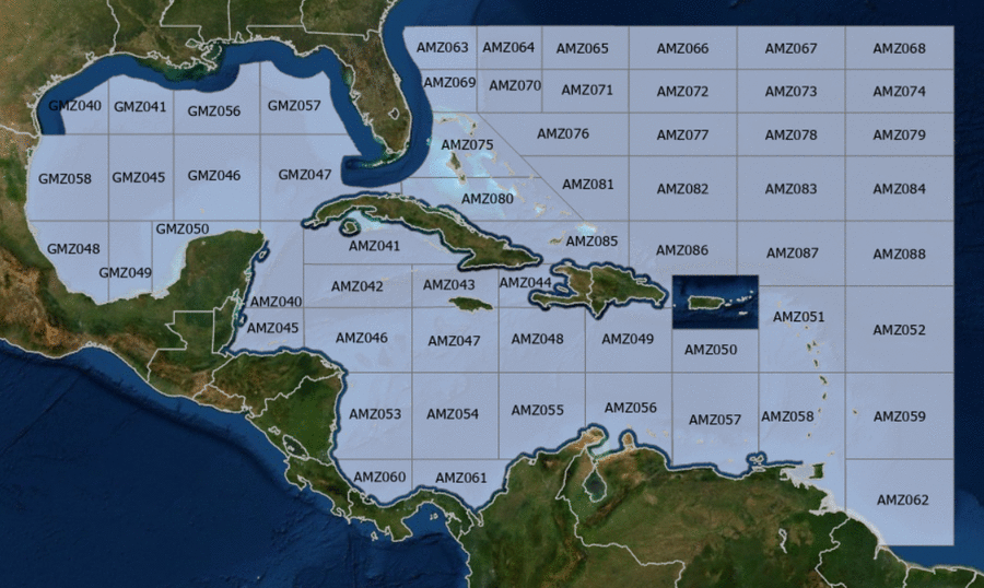
Hover to view popup zone forecast; click a zone to view related text forecast below. Show All Text Below
000
FZNT23 KNHC 152032
OFFNT3

Offshore Waters Forecast for the Caribbean Sea and Tropical
N Atlantic
NWS National Hurricane Center Miami, FL
432 PM EDT Wed May 15 2024

Offshore Waters Forecast for Caribbean Sea, and the Tropical N
Atlantic from 07N to 19N W of 55W.

Seas given as significant wave height, which is the average
height of the highest 1/3 of the waves. Individual waves may be
more than twice the significant wave height.
AMZ001-160845-
Synopsis for Caribbean Sea, and Tropical N Atlantic from 07N to
19N W of 55W
432 PM EDT Wed May 15 2024

.SYNOPSIS...High pressure centered SE of Bermuda is supporting
fresh to strong E to SE winds in the Gulf of Honduras and fresh
to strong NE to E winds in the south-central Caribbean. The
strong winds in the Gulf of Honduras will persist through Sun,
reaching near gale-force speeds Fri evening into Sat morning.
Moderate to rough seas are expected with these winds. Fresh to
strong winds will pulse at night in the Gulf of Venezuala and
offshore Colombia through Sun evening. Gentle to moderate winds
are expected elsewhere through early next week. Meanwhile, haze
due to agricultural fires in Central America continues across
some areas of the NW Caribbean.
AMZ040-160845-
Caribbean N of 18N W of 85W including Yucatan Basin-
432 PM EDT Wed May 15 2024

.TONIGHT...E to SE winds 15 to 20 kt. Seas 4 to 6 ft.
.THU...SE winds 20 to 25 kt. Seas 3 to 5 ft in Yucatan Channel,
and 5 to 7 ft elsewhere.
.THU NIGHT...E to SE winds 20 to 25 kt. Seas 3 to 5 ft in
Yucatan Channel, and 5 to 7 ft elsewhere.
.FRI...SE winds 20 to 25 kt. Seas 3 to 5 ft in Yucatan Channel,
and 6 to 8 ft elsewhere.
.FRI NIGHT...SE winds 20 to 25 kt. Seas 6 to 9 ft.
.SAT...SE winds 20 to 25 kt. Seas 6 to 9 ft.
.SAT NIGHT...E to SE winds 20 to 25 kt. Seas 4 to 6 ft.
.SUN...SE winds 15 to 20 kt. Seas 4 to 6 ft.
.SUN NIGHT...E to SE winds 15 to 20 kt. Seas 2 to 4 ft.
.MON...E to SE winds 10 to 15 kt. Seas 2 to 4 ft.
.MON NIGHT...E to SE winds 10 to 15 kt. Seas 2 to 4 ft.
Forecaster Ramos
AMZ041-160845-
Caribbean N of 20N E of 85W-
432 PM EDT Wed May 15 2024

.TONIGHT...SE to S winds 10 to 15 kt. Seas 2 to 4 ft.
.THU...SE to S winds 10 to 15 kt. Seas 2 to 4 ft.
.THU NIGHT...SE winds 10 to 15 kt. Seas 2 to 4 ft.
.FRI...SE winds 15 to 20 kt. Seas 2 to 4 ft.
.FRI NIGHT...SE winds 15 to 20 kt. Seas 2 to 4 ft.
.SAT...SE winds 15 to 20 kt. Seas 2 to 4 ft.
.SAT NIGHT...SE winds 10 to 15 kt. Seas 2 to 4 ft.
.SUN...SE winds 10 to 15 kt. Seas 2 to 4 ft.
.SUN NIGHT...SE to S winds 10 kt. Seas 3 ft or less.
.MON...E to SE winds 10 kt. Seas 3 ft or less.
.MON NIGHT...SE winds 10 kt. Seas 3 ft or less.
Forecaster Ramos
AMZ042-160845-
Caribbean from 18N to 20N between 80W and 85W including Cayman
Basin-
432 PM EDT Wed May 15 2024

.TONIGHT...SE winds 15 to 20 kt. Seas 3 to 5 ft.
.THU...SE winds 15 to 20 kt. Seas 3 to 5 ft.
.THU NIGHT...SE winds 15 to 20 kt. Seas 3 to 5 ft.
.FRI...SE winds 15 to 20 kt. Seas 3 to 5 ft.
.FRI NIGHT...SE winds 15 to 20 kt. Seas 3 to 5 ft.
.SAT...SE winds 15 to 20 kt. Seas 3 to 5 ft.
.SAT NIGHT...E to SE winds 15 to 20 kt. Seas 2 to 4 ft.
.SUN...E to SE winds 10 to 15 kt. Seas 2 to 4 ft.
.SUN NIGHT...E to SE winds 10 to 15 kt. Seas 2 to 4 ft.
.MON...E winds 10 to 15 kt. Seas 2 to 4 ft.
.MON NIGHT...E to SE winds 10 to 15 kt. Seas 3 ft or less.
Forecaster Ramos
AMZ043-160845-
Caribbean from 18N to 20N between 76W and 80W-
432 PM EDT Wed May 15 2024

.TONIGHT...E to SE winds 10 to 15 kt. Seas 2 to 4 ft.
.THU...SE winds 10 to 15 kt. Seas 2 to 4 ft.
.THU NIGHT...E to SE winds 10 to 15 kt. Seas 2 to 4 ft.
.FRI...E to SE winds 10 to 15 kt. Seas 3 ft or less.
.FRI NIGHT...E to SE winds 10 to 15 kt. Seas 2 to 4 ft.
.SAT...E to SE winds 10 to 15 kt. Seas 2 to 4 ft.
.SAT NIGHT...E to SE winds 10 kt. Seas 3 ft or less.
.SUN...E winds 10 to 15 kt. Seas 2 to 4 ft.
.SUN NIGHT...E to SE winds 10 kt. Seas 3 ft or less.
.MON...E winds 10 kt. Seas 3 ft or less.
.MON NIGHT...E to SE winds 10 kt. Seas 3 ft or less.
Forecaster Ramos
AMZ044-160845-
Caribbean approaches to the Windward Passage-
432 PM EDT Wed May 15 2024

.TONIGHT...S winds 10 kt, shifting to E late. Seas
2 to 4 ft.
.THU...SE winds 10 kt, shifting to S to SW in the afternoon.
Seas 3 ft or less.
.THU NIGHT...S to SW winds 10 kt, shifting to E late.
Seas 3 ft or less.
.FRI...E to SE winds 10 to 15 kt. Seas 3 ft or less.
.FRI NIGHT...NE to E winds 10 kt. Seas 3 ft or less.
.SAT...NE to E winds 10 kt. Seas 3 ft or less.
.SAT NIGHT...NE to E winds 10 to 15 kt. Seas 3 ft or less.
.SUN...NE to E winds 10 to 15 kt. Seas 3 ft or less.
.SUN NIGHT...E winds 10 to 15 kt. Seas 3 ft or less.
.MON...E winds 10 kt. Seas 3 ft or less.
.MON NIGHT...E to SE winds 10 to 15 kt. Seas 3 ft or less.
Forecaster Ramos
AMZ045-160845-
S of 18N W of 85W including Gulf of Honduras-
432 PM EDT Wed May 15 2024

.TONIGHT...E winds 20 to 25 kt S of 17N W of 87W, and E to SE
20 to 30 kt elsewhere. Seas 4 to 6 ft.
.THU...S of 17N W of 87W, S winds 15 to 20 kt, shifting to NE to
E 10 kt in the afternoon. Elsewhere, E to SE winds 20 to 25 kt.
Seas 5 to 7 ft.
.THU NIGHT...E winds 15 to 20 kt S of 17N W of 87W, and E to SE
20 to 30 kt elsewhere. S of 17N W of 87W, seas 2 to 4 ft,
building to 4 to 6 ft late. Elsewhere, seas 6 to 8 ft.
.FRI...S of 17N W of 87W, E winds 10 to 15 kt. Seas 4 to 6 ft.
Elsewhere, E to SE winds 20 to 25 kt. Seas 6 to 8 ft.
.FRI NIGHT...E to SE winds 25 to 30 kt. Seas 6 to 9 ft.
.SAT...E to SE winds 20 to 25 kt. Seas 6 to 8 ft.
.SAT NIGHT...E to SE winds 25 to 30 kt. Seas 5 to 7 ft.
.SUN...E to SE winds 15 to 20 kt. Seas 4 to 6 ft.
.SUN NIGHT...E winds 20 to 25 kt. Seas 3 to 5 ft.
.MON...E to SE winds 15 to 20 kt. Seas 3 to 5 ft.
.MON NIGHT...E winds 15 to 20 kt. Seas 2 to 4 ft.
Forecaster Ramos
AMZ046-160845-
Caribbean from 15N to 18N between 80W and 85W-
432 PM EDT Wed May 15 2024

.TONIGHT...E to SE winds 15 to 20 kt. Seas 2 to 4 ft.
.THU...E to SE winds 15 to 20 kt. Seas 2 to 4 ft.
.THU NIGHT...E to SE winds 15 to 20 kt. Seas 2 to 4 ft.
.FRI...E to SE winds 15 to 20 kt. Seas 2 to 4 ft.
.FRI NIGHT...E to SE winds 20 to 25 kt. Seas 2 to 4 ft.
.SAT...E to SE winds 15 to 20 kt. Seas 2 to 4 ft.
.SAT NIGHT...E to SE winds 15 to 20 kt. Seas 2 to 4 ft.
.SUN...E to SE winds 15 kt. Seas 2 to 4 ft.
.SUN NIGHT...E winds 15 to 20 kt. Seas 2 to 4 ft.
.MON...E winds 15 kt. Seas 2 to 4 ft.
.MON NIGHT...E winds 10 to 15 kt. Seas 2 to 4 ft.
Forecaster Ramos
AMZ047-160845-
Caribbean from 15N to 18N between 76W and 80W-
432 PM EDT Wed May 15 2024

.TONIGHT...E winds 15 kt. Seas 3 to 5 ft.
.THU...E to SE winds 15 kt. Seas 3 to 5 ft.
.THU NIGHT...E winds 15 kt. Seas 2 to 4 ft.
.FRI...E to SE winds 15 kt. Seas 2 to 4 ft.
.FRI NIGHT...E winds 15 kt. Seas 2 to 4 ft.
.SAT...E winds 15 kt. Seas 2 to 4 ft.
.SAT NIGHT...E winds 15 to 20 kt. Seas 2 to 4 ft.
.SUN...E winds 15 to 20 kt. Seas 2 to 4 ft.
.SUN NIGHT...E winds 10 to 15 kt. Seas 2 to 4 ft.
.MON...E winds 15 to 20 kt. Seas 3 to 5 ft.
.MON NIGHT...E winds 15 to 20 kt. Seas 3 to 5 ft.
Forecaster Ramos
AMZ048-160845-
Caribbean from 15N to 18N between 72W and 76W-
432 PM EDT Wed May 15 2024

.TONIGHT...E winds 10 to 15 kt. Seas 3 to 5 ft.
.THU...E winds 10 to 15 kt. Seas 3 to 5 ft.
.THU NIGHT...E winds 10 to 15 kt. Seas 2 to 4 ft.
.FRI...E winds 15 kt. Seas 2 to 4 ft.
.FRI NIGHT...E winds 10 to 15 kt. Seas 2 to 4 ft.
.SAT...E winds 10 to 15 kt. Seas 3 to 5 ft.
.SAT NIGHT...E winds 15 to 20 kt. Seas 3 to 5 ft.
.SUN...E winds 15 kt. Seas 3 to 5 ft.
.SUN NIGHT...E winds 15 to 20 kt. Seas 3 to 5 ft.
.MON...E winds 15 to 20 kt. Seas 4 to 6 ft.
.MON NIGHT...E winds 15 to 20 kt. Seas 3 to 5 ft.
Forecaster Ramos
AMZ049-160845-
Caribbean N of 15N between 68W and 72W-
432 PM EDT Wed May 15 2024

.TONIGHT...E winds 10 to 15 kt. Seas 2 to 4 ft.
.THU...E winds 10 to 15 kt. Seas 2 to 4 ft.
.THU NIGHT...E winds 10 to 15 kt. Seas 2 to 4 ft.
.FRI...E winds 10 to 15 kt. Seas 2 to 4 ft.
.FRI NIGHT...E winds 10 to 15 kt. Seas 2 to 4 ft.
.SAT...E winds 10 to 15 kt. Seas 2 to 4 ft.
.SAT NIGHT...E winds 10 to 15 kt. Seas 2 to 4 ft.
.SUN...E winds 10 to 15 kt. Seas 2 to 4 ft.
.SUN NIGHT...E winds 10 to 15 kt. Seas 2 to 4 ft.
.MON...E winds 15 to 20 kt. Seas 3 to 5 ft.
.MON NIGHT...E winds 15 to 20 kt. Seas 3 to 5 ft.
Forecaster Ramos
AMZ050-160845-
Caribbean N of 15N between 64W and 68W-
432 PM EDT Wed May 15 2024

.TONIGHT...E winds 10 to 15 kt. Seas 2 to 4 ft.
.THU...E winds 10 to 15 kt. Seas 2 to 4 ft.
.THU NIGHT...E winds 10 to 15 kt. Seas 2 to 4 ft.
.FRI...E winds 10 to 15 kt. Seas 2 to 4 ft.
.FRI NIGHT...E winds 10 to 15 kt. Seas 2 to 4 ft.
.SAT...E winds 10 to 15 kt. Seas 2 to 4 ft.
.SAT NIGHT...E winds 10 to 15 kt. Seas 2 to 4 ft.
.SUN...E to SE winds 10 to 15 kt. Seas 2 to 4 ft.
.SUN NIGHT...E to SE winds 10 to 15 kt. Seas 2 to 4 ft.
.MON...E to SE winds 10 to 15 kt. Seas 2 to 4 ft.
.MON NIGHT...E winds 10 to 15 kt. Seas 2 to 4 ft.
Forecaster Ramos
AMZ051-160845-
Offshore Waters Leeward Islands-
432 PM EDT Wed May 15 2024

.TONIGHT...E winds 10 to 15 kt. Seas 2 to 4 ft.
.THU...E winds 10 kt. Seas 2 to 4 ft.
.THU NIGHT...E winds 10 to 15 kt. Seas 2 to 4 ft.
.FRI...E to SE winds 10 to 15 kt. Seas 2 to 4 ft.
.FRI NIGHT...E winds 10 to 15 kt. Seas 2 to 4 ft.
.SAT...E winds 10 to 15 kt. Seas 2 to 4 ft.
.SAT NIGHT...E winds 10 to 15 kt. Seas 2 to 4 ft.
.SUN...E to SE winds 10 to 15 kt. Seas 2 to 4 ft.
.SUN NIGHT...E to SE winds 10 to 15 kt. Seas 2 to 4 ft.
.MON...E to SE winds 10 to 15 kt. Seas 2 to 4 ft.
.MON NIGHT...E winds 10 to 15 kt. Seas 2 to 4 ft.
Forecaster Ramos
AMZ052-160845-
Tropical N Atlantic from 15N to 19N between 55W and 60W-
432 PM EDT Wed May 15 2024

.TONIGHT...E winds 10 to 15 kt. Seas 3 to 5 ft.
.THU...E to SE winds 10 to 15 kt. Seas 3 to 5 ft.
.THU NIGHT...E winds 10 to 15 kt. Seas 3 to 5 ft.
.FRI...E to SE winds 10 to 15 kt. Seas 3 to 5 ft.
.FRI NIGHT...E winds 10 to 15 kt. Seas 3 to 5 ft.
.SAT...E winds 10 to 15 kt. Seas 4 to 6 ft.
.SAT NIGHT...E winds 10 to 15 kt. Seas 3 to 5 ft.
.SUN...E winds 10 to 15 kt. Seas 3 to 5 ft.
.SUN NIGHT...E winds 10 to 15 kt. Seas 3 to 5 ft.
.MON...E winds 10 to 15 kt. Seas 3 to 5 ft.
.MON NIGHT...E winds 10 to 15 kt. Seas 3 to 5 ft.
Forecaster Ramos
AMZ053-160845-
W Central Caribbean from 11N to 15N W of 80W-
432 PM EDT Wed May 15 2024

.TONIGHT...E winds 10 to 15 kt. Seas 4 to 6 ft. Scattered
showers and isolated tstms.
.THU...E winds 15 to 20 kt. Seas 3 to 5 ft. Scattered showers
and isolated tstms.
.THU NIGHT...E to SE winds 10 to 15 kt. Seas 2 to 4 ft.
Scattered showers and isolated tstms.
.FRI...E winds 10 to 15 kt. Seas 2 to 4 ft. Scattered showers
and isolated tstms.
.FRI NIGHT...E winds 10 to 15 kt. Seas 2 to 4 ft.
.SAT...E winds 10 to 15 kt. Seas 2 to 4 ft.
.SAT NIGHT...NE to E winds 15 to 20 kt. Seas 3 to 5 ft.
.SUN...NE to E winds 10 to 15 kt. Seas 3 to 5 ft.
.SUN NIGHT...NE to E winds 15 kt. Seas 3 to 5 ft.
.MON...NE to E winds 15 to 20 kt. Seas 3 to 5 ft.
.MON NIGHT...NE to E winds 10 to 15 kt. Seas 3 to 5 ft.
Forecaster Ramos
AMZ054-160845-
Caribbean from 11N to 15N between 76W and 80W-
432 PM EDT Wed May 15 2024

.TONIGHT...E winds 10 to 15 kt. Seas 4 to 6 ft. Scattered
showers and isolated tstms.
.THU...E winds 10 to 15 kt. Seas 3 to 5 ft.
.THU NIGHT...NE to E winds 15 to 20 kt. Seas 3 to 5 ft.
.FRI...E winds 15 to 20 kt. Seas 3 to 5 ft.
.FRI NIGHT...NE to E winds 15 to 20 kt. Seas 3 to 5 ft.
.SAT...NE to E winds 15 to 20 kt. Seas 4 to 6 ft.
.SAT NIGHT...NE to E winds 15 to 20 kt. Seas 4 to 6 ft.
.SUN...NE to E winds 15 to 20 kt. Seas 5 to 7 ft.
.SUN NIGHT...NE to E winds 15 to 20 kt. Seas 5 to 7 ft.
.MON...NE to E winds 15 to 20 kt. Seas 4 to 6 ft.
.MON NIGHT...E winds 15 to 20 kt. Seas 3 to 5 ft.
Forecaster Ramos
AMZ055-160845-
Caribbean from 11N to 15N between 72W and 76W including Colombia
Basin-
432 PM EDT Wed May 15 2024

.TONIGHT...Within 90 nm of coast of Colombia, NE winds 10 to
15 kt. Seas 2 to 4 ft. Elsewhere, NE to E winds 15 to 20 kt. Seas
4 to 6 ft.
.THU...E winds 15 to 20 kt. Seas 3 to 5 ft.
.THU NIGHT...NE to E winds 15 to 20 kt. Seas 3 to 5 ft.
.FRI...NE to E winds 15 to 20 kt within 90 nm of coast of
Colombia, and E 15 to 20 kt elsewhere. Seas 4 to 6 ft.
.FRI NIGHT...NE to E winds 20 to 25 kt. Seas 5 to 7 ft.
.SAT...NE to E winds 15 to 20 kt. Seas 4 to 6 ft.
.SAT NIGHT...NE to E winds 20 to 25 kt. Seas 5 to 7 ft.
.SUN...NE to E winds 15 to 20 kt. Seas 5 to 7 ft.
.SUN NIGHT...NE to E winds 20 to 25 kt. Seas 5 to 7 ft.
.MON...E winds 15 to 20 kt. Seas 4 to 6 ft.
.MON NIGHT...E winds 15 to 20 kt. Seas 4 to 6 ft.
Forecaster Ramos
AMZ056-160845-
Caribbean S of 15N between 68W and 72W including Gulf of
Venezuela-
432 PM EDT Wed May 15 2024

.TONIGHT...NE to E winds 20 to 25 kt Gulf of Venezuela, and E
15 to 20 kt elsewhere. Seas 3 to 5 ft.
.THU...E winds 15 to 20 kt. Seas 2 to 4 ft.
.THU NIGHT...NE to E winds 20 to 25 kt Gulf of Venezuela, and E
15 to 20 kt elsewhere. Seas 3 to 5 ft.
.FRI...NE to E winds 15 to 20 kt Gulf of Venezuela, and E 15 to
20 kt elsewhere. Seas 3 to 5 ft.
.FRI NIGHT...E winds 15 to 20 kt. Seas 3 to 5 ft.
.SAT...E winds 15 to 20 kt. Seas 3 to 5 ft.
.SAT NIGHT...E winds 15 to 20 kt. Seas 4 to 6 ft.
.SUN...E winds 15 to 20 kt. Seas 3 to 5 ft.
.SUN NIGHT...E winds 15 to 20 kt. Seas 4 to 6 ft.
.MON...E winds 15 to 20 kt. Seas 4 to 6 ft.
.MON NIGHT...E winds 20 kt. Seas 4 to 6 ft.
Forecaster Ramos
AMZ057-160845-
Caribbean S of 15N between 64W and 68W including Venezuela Basin-
432 PM EDT Wed May 15 2024

.TONIGHT...E winds 15 kt. Seas 2 to 4 ft.
.THU...E winds 10 to 15 kt. Seas 2 to 4 ft.
.THU NIGHT...NE to E winds 15 to 20 kt. Seas 2 to 4 ft.
.FRI...E winds 15 to 20 kt. Seas 2 to 4 ft.
.FRI NIGHT...E winds 15 to 20 kt. Seas 3 to 5 ft.
.SAT...E winds 15 to 20 kt. Seas 3 to 5 ft.
.SAT NIGHT...E winds 15 to 20 kt. Seas 3 to 5 ft.
.SUN...E to SE winds 15 to 20 kt. Seas 3 to 5 ft.
.SUN NIGHT...E winds 15 to 20 kt. Seas 2 to 4 ft.
.MON...E to SE winds 15 to 20 kt. Seas 2 to 4 ft.
.MON NIGHT...E winds 15 to 20 kt. Seas 2 to 4 ft.
Forecaster Ramos
AMZ058-160845-
Offshore Waters Windward Islands including Trinidad and Tobago-
432 PM EDT Wed May 15 2024

.TONIGHT...E winds 10 to 15 kt. Seas 2 to 4 ft.
.THU...E winds 10 to 15 kt. Seas 2 to 4 ft.
.THU NIGHT...E winds 10 to 15 kt. Seas 2 to 4 ft. Scattered
showers and isolated tstms.
.FRI...E winds 10 to 15 kt. Seas 2 to 4 ft.
.FRI NIGHT...E winds 10 to 15 kt. Seas 3 to 5 ft.
.SAT...E winds 10 to 15 kt. Seas 3 to 5 ft.
.SAT NIGHT...E winds 15 to 20 kt. Seas 3 to 5 ft.
.SUN...E to SE winds 10 to 15 kt. Seas 3 to 5 ft.
.SUN NIGHT...E winds 10 to 15 kt. Seas 2 to 4 ft.
.MON...E to SE winds 10 to 15 kt. Seas 2 to 4 ft.
.MON NIGHT...E winds 10 to 15 kt. Seas 2 to 4 ft.
Forecaster Ramos
AMZ059-160845-
Tropical N Atlantic from 11N and 15N between 55W and 60W-
432 PM EDT Wed May 15 2024

.TONIGHT...E winds 10 to 15 kt. Seas 4 to 6 ft.
.THU...E winds 15 kt. Seas 4 to 6 ft.
.THU NIGHT...E winds 15 kt. Seas 4 to 6 ft. Scattered showers
and isolated tstms.
.FRI...E winds 15 kt. Seas 4 to 6 ft.
.FRI NIGHT...E winds 15 to 20 kt. Seas 4 to 6 ft.
.SAT...E winds 15 kt. Seas 4 to 6 ft.
.SAT NIGHT...E winds 15 kt. Seas 4 to 6 ft.
.SUN...E winds 10 to 15 kt. Seas 4 to 6 ft.
.SUN NIGHT...E winds 15 kt. Seas 4 to 6 ft.
.MON...E winds 10 to 15 kt. Seas 4 to 6 ft.
.MON NIGHT...E winds 15 kt. Seas 3 to 5 ft.
Forecaster Ramos
AMZ060-160845-
SW Caribbean S of 11N W of 80W-
432 PM EDT Wed May 15 2024

.TONIGHT...S of 10N, S to SW winds 10 kt in the evening,
becoming variable less than 5 kt. Elsewhere, E to SE winds
10 kt, shifting to S late. Seas 3 to 5 ft.
.THU...S winds 10 kt in the morning, becoming variable less than
5 kt. Seas 2 to 4 ft. Scattered showers and isolated tstms.
.THU NIGHT...E winds 10 kt. Seas 2 to 4 ft. Scattered showers
and isolated tstms.
.FRI...S of 10N, variable winds less than 5 kt in the morning.
Variable winds less than 5 kt in the afternoon. Elsewhere, E to
SE winds 10 kt in the morning. Seas 3 ft or less. Scattered
showers and isolated tstms.
.FRI NIGHT...NE winds 10 kt. Seas 2 to 4 ft.
.SAT...NE winds 10 kt. Seas 2 to 4 ft.
.SAT NIGHT...N to NE winds 10 kt. Seas 2 to 4 ft.
.SUN...N to NE winds 10 to 15 kt. Seas 3 to 5 ft.
.SUN NIGHT...N to NE winds 10 kt. Seas 3 to 5 ft.
.MON...NW to N winds 10 kt. Seas 3 to 5 ft.
.MON NIGHT...E to SE winds 10 kt. Seas 2 to 4 ft.
Forecaster Ramos
AMZ061-160845-
SW Caribbean S of 11N E of 80W including the approaches to the
Panama Canal-
432 PM EDT Wed May 15 2024

.TONIGHT...SW to W winds 10 kt. Seas 3 to 5 ft. Scattered
showers and isolated tstms.
.THU...S of 10N, variable winds less than 5 kt, becoming W 10 kt
in the afternoon. Elsewhere, NE to E winds 10 kt in the morning,
becoming variable less than 5 kt. Seas 2 to 4 ft.
.THU NIGHT...S of 10N, NW to N winds 10 kt in the evening,
becoming variable less than 5 kt. Elsewhere, NE winds 10 to
15 kt. Seas 2 to 4 ft. Scattered showers and isolated tstms.
.FRI...Variable winds less than 5 kt S of 10N, and E 10 to 15 kt
elsewhere. Seas 2 to 4 ft.
.FRI NIGHT...N winds 10 to 15 kt. Seas 2 to 4 ft.
.SAT...NE winds 10 kt. Seas 3 to 5 ft.
.SAT NIGHT...N to NE winds 10 to 15 kt. Seas 3 to 5 ft.
.SUN...E winds 10 to 15 kt. Seas 3 to 5 ft.
.SUN NIGHT...NW to N winds 10 kt. Seas 3 to 5 ft.
.MON...S winds 10 kt. Seas 3 to 5 ft.
.MON NIGHT...S winds 10 kt. Seas 2 to 4 ft.
Forecaster Ramos
AMZ062-160845-
Tropical N Atlantic from 7N and 11N between 55W and 60W-
432 PM EDT Wed May 15 2024

.TONIGHT...E winds 10 to 15 kt. Seas 3 to 5 ft. Scattered
showers and isolated tstms.
.THU...E winds 10 to 15 kt. Seas 3 to 5 ft. Scattered showers
and isolated tstms.
.THU NIGHT...E winds 10 to 15 kt. Seas 3 to 5 ft. Scattered
showers and isolated tstms.
.FRI...E winds 15 kt. Seas 3 to 5 ft. Scattered showers and
isolated tstms.
.FRI NIGHT...E winds 15 kt. Seas 4 to 6 ft.
.SAT...E winds 15 kt. Seas 4 to 6 ft.
.SAT NIGHT...E winds 15 kt. Seas 4 to 6 ft.
.SUN...E winds 10 to 15 kt. Seas 4 to 6 ft.
.SUN NIGHT...NE to E winds 10 to 15 kt. Seas 3 to 5 ft.
.MON...E winds 10 to 15 kt. Seas 3 to 5 ft.
.MON NIGHT...E winds 10 to 15 kt. Seas 3 to 5 ft.
Forecaster Ramos
625
FZNT25 KNHC 152047
OFFNT5

Offshore Waters Forecast for the SW N Atlantic including the
Bahamas
NWS National Hurricane Center Miami, FL
447 PM EDT Wed May 15 2024

Offshore Waters Forecast for the SW N Atlantic from 19N to 31N W
of 55W including Bahamas.

Seas given as significant wave height, which is the average
height of the highest 1/3 of the waves. Individual waves may be
more than twice the significant wave height.
AMZ101-160900-
Synopsis for the SW N Atlantic including the Bahamas
447 PM EDT Wed May 15 2024

.SYNOPSIS...Fresh to locally strong SW winds and moderate seas
are ongoing N of 29N between the NE Florida offshore waters and
67W as a cold front approaches from the west. A pre-frontal trough
continues to fire up heavy showers and thunderstorms with
frequent lightning and gusty winds across the central and portions
of the south Florida seaboard as well as the northern Bahamas.
The cold front will push off the NE Florida coast tonight and
extend from 31N73W to Freeport Thu afternoon, from 31N65W to
27N69W Fri afternoon and weaken as it extends from 31N61W to
28N71W Sat morning. Fresh to strong winds are forecast ahead of
the front through Fri night along with showers and thunderstorms.
Conditions will improve Sat as the front dissipates. Tranquil
conditions are expected the remainder weekend.
AMZ063-160900-
Atlantic from 29N to 31N W of 77W-
447 PM EDT Wed May 15 2024

.TONIGHT...SW to W winds 15 to 20 kt. Seas 5 to 7 ft. Scattered
showers and isolated tstms.
.THU...W to NW winds 10 to 15 kt. Seas 4 to 6 ft.
.THU NIGHT...W of 79W, variable winds less than 5 kt in the
evening. Variable winds less than 5 kt late. E of 79W,
NW to N winds 10 kt in the evening. Seas 3 to 5 ft.
.FRI...W of 79W, variable winds less than 5 kt, becoming SE 10 kt
in the afternoon. E of 79W, variable winds less than 5 kt. Seas
2 to 4 ft.
.FRI NIGHT...SE winds 10 to 15 kt. Seas 3 ft or less.
.SAT...S winds 10 kt. Seas 2 to 4 ft.
.SAT NIGHT...Winds S to SW winds 15 to 20 kt. Seas 3 to 5 ft.
.SUN...SW winds 10 to 15 kt. Seas 3 to 5 ft.
.SUN NIGHT...W winds 10 to 15 kt W of 79W, and SW 15 to 20 kt E
of 79W. Seas 5 to 7 ft in NE to E swell.
.MON...NW winds 10 to 15 kt. Seas 5 to 7 ft in NE to E swell.
.MON NIGHT...NW to N winds 10 to 15 kt. Seas 3 to 5 ft.
Forecaster Ramos
AMZ064-160900-
Atlantic from 29N to 31N between 74W and 77W-
447 PM EDT Wed May 15 2024

.TONIGHT...SW winds 20 to 25 kt W of 75W, and S to SW 15 to 20 kt
E of 75W. Seas 5 to 7 ft. Numerous showers and scattered tstms.
.THU...W winds 10 to 15 kt. Seas 5 to 7 ft in SW to W swell.
.THU NIGHT...NW winds 10 to 15 kt. Seas 4 to 6 ft.
.FRI...Variable winds less than 5 kt. Seas 3 to 5 ft in E to SE
swell.
.FRI NIGHT...Variable winds less than 5 kt. Seas 2 to 4 ft in N
to NE swell.
.SAT...W of 75W, SE to S winds 10 kt. E of 75W, variable winds
less than 5 kt, becoming S 10 kt in the afternoon. Seas 2 to 4 ft
in N to NE swell.
.SAT NIGHT...S to SW winds 10 to 15 kt. Seas 2 to 4 ft.
.SUN...SW winds 10 to 15 kt. Seas 3 to 5 ft.
.SUN NIGHT...SW winds 20 to 25 kt W of 75W, and SW 15 to 20 kt E
of 75W. Seas 5 to 7 ft in NE swell.
.MON...W winds 15 to 20 kt. Seas 5 to 7 ft.
.MON NIGHT...W winds 10 to 15 kt. Seas 5 to 7 ft in N to NE
swell.
Forecaster Ramos
AMZ065-160900-
Atlantic from 29N to 31N between 70W and 74W-
447 PM EDT Wed May 15 2024

.TONIGHT...S to SW winds 20 to 25 kt. Seas 6 to 8 ft. Numerous
showers and scattered tstms.
.THU...SW winds 15 to 20 kt W of 72W, and S to SW 20 to 25 kt E
of 72W. Seas 6 to 9 ft in SW to W swell. Scattered showers and
isolated tstms.
.THU NIGHT...W to NW winds 10 to 15 kt. Seas 6 to 8 ft in SW to W
swell.
.FRI...W of 72W, N winds 10 kt in the morning, becoming variable
less than 5 kt. E of 72W, NW winds 10 kt. Seas 4 to 6 ft.
.FRI NIGHT...NW winds 10 to 15 kt. Seas 4 to 6 ft.
.SAT...Variable winds less than 5 kt W of 72W, and NW 10 kt E of
72W. Seas 4 to 6 ft.
.SAT NIGHT...W of 72W, variable winds less than 5 kt, becoming S
10 kt late. E of 72W, NW to N winds 10 kt in the
evening, becoming variable less than 5 kt. Seas 3 to 5 ft.
.SUN...SW winds 10 to 15 kt. Seas 3 to 5 ft.
.SUN NIGHT...SW winds 15 to 20 kt W of 72W, and S to SW 10 to
15 kt E of 72W. Seas 4 to 6 ft.
.MON...W of 72W, SW winds 15 to 20 kt. E of 72W, S to SW winds
10 to 15 kt, increasing to 20 kt in the afternoon. Seas 5 to 7 ft
in N to NE swell.
.MON NIGHT...SW to W winds 10 to 15 kt W of 72W, and SW 15 to
20 kt E of 72W. Seas 5 to 7 ft in NW to N swell.
Forecaster Ramos
AMZ066-160900-
Atlantic from 29N to 31N between 65W and 70W-
447 PM EDT Wed May 15 2024

.TONIGHT...S to SW winds 15 to 20 kt W of 67W, and S 15 to 20 kt
E of 67W. Seas 5 to 7 ft. Scattered showers and isolated tstms.
.THU...SW winds 20 to 25 kt W of 67W, and S to SW 15 to 20 kt E
of 67W. Seas 6 to 9 ft in SW to W swell. Scattered showers and
isolated tstms.
.THU NIGHT...W of 67W, SW winds 20 to 25 kt, becoming SW to W
10 to 15 kt late. E of 67W, SW winds 15 to 20 kt. Seas
6 to 9 ft in W swell. Scattered showers and isolated tstms.
.FRI...W to NW winds 10 to 15 kt W of 67W, and SW to W 15 to
20 kt E of 67W. Seas 6 to 8 ft.
.FRI NIGHT...W to NW winds 10 to 15 kt. Seas 4 to 6 ft.
.SAT...W to NW winds 10 to 15 kt. Seas 5 to 7 ft in NW swell.
.SAT NIGHT...NW winds 10 to 15 kt. Seas 4 to 6 ft.
.SUN...W of 67W, variable winds less than 5 kt, becoming W 10 kt
in the afternoon. E of 67W, W to NW winds 10 kt. Seas 3 to 5 ft.
.SUN NIGHT...W of 67W, SW winds 10 to 15 kt. E of 67W, variable
winds less than 5 kt, becoming SW 10 kt late. Seas 3 to
5 ft.
.MON...SW winds 10 to 15 kt. Seas 4 to 6 ft.
.MON NIGHT...S to SW winds 10 to 15 kt. Seas 5 to 7 ft in NW
swell.
Forecaster Ramos
AMZ067-160900-
Atlantic from 29N to 31N between 60W and 65W-
447 PM EDT Wed May 15 2024

.TONIGHT...W of 62W, S winds 10 kt late. Variable winds
less than 5 kt in the evening. E of 62W, variable less than 5 kt.
Seas 4 to 6 ft in N swell.
.THU...S to SW winds 10 to 15 kt. Seas 4 to 6 ft.
.THU NIGHT...S to SW winds 15 to 20 kt W of 62W, and S to SW
10 to 15 kt E of 62W. Seas 6 to 8 ft in W to NW swell. Scattered
showers and isolated tstms.
.FRI...S to SW winds 15 to 20 kt. Seas 6 to 8 ft in W to NW
swell. Scattered showers and isolated tstms.
.FRI NIGHT...SW to W winds 10 to 15 kt W of 62W, and SW 15 to
20 kt E of 62W. Seas 6 to 8 ft in W swell.
.SAT...SW to W winds 10 to 15 kt. Seas 5 to 7 ft in W swell.
.SAT NIGHT...W winds 10 to 15 kt. Seas 4 to 6 ft.
.SUN...W winds 10 to 15 kt. Seas 3 to 5 ft.
.SUN NIGHT...W winds 10 kt. Seas 3 to 5 ft.
.MON...W winds 10 kt. Seas 2 to 4 ft.
.MON NIGHT...W of 62W, SW winds 10 kt. E of 62W, variable winds
less than 5 kt, becoming SW to W 10 kt late. Seas 3 to
5 ft.
Forecaster Ramos
AMZ068-160900-
Atlantic from 29N to 31N between 55W and 60W-
447 PM EDT Wed May 15 2024

.TONIGHT...W to NW winds 10 kt in the evening, becoming variable
less than 5 kt. Seas 4 to 6 ft in NW to N swell.
.THU...Variable winds less than 5 kt, becoming SW 10 kt in the
afternoon. Seas 4 to 6 ft in NW to N swell.
.THU NIGHT...W of 57W, S to SW winds 10 to 15 kt. E of 57W,
variable winds less than 5 kt, becoming S 10 kt late.
Seas 3 to 5 ft.
.FRI...S to SW winds 10 to 15 kt. Seas 4 to 6 ft.
.FRI NIGHT...S winds 15 to 20 kt W of 57W, and S 10 to 15 kt E of
57W. Seas 5 to 7 ft in W swell.
.SAT...SW winds 15 to 20 kt W of 57W, and S to SW 10 to 15 kt E
of 57W. Seas 5 to 7 ft in W to NW swell.
.SAT NIGHT...SW winds 10 to 15 kt. Seas 5 to 7 ft in W swell.
.SUN...SW to W winds 10 to 15 kt. Seas 3 to 5 ft.
.SUN NIGHT...SW to W winds 10 to 15 kt. Seas 3 to 5 ft.
.MON...SW to W winds 10 to 15 kt. Seas 3 to 5 ft.
.MON NIGHT...W winds 10 kt. Seas 3 to 5 ft.
Forecaster Ramos
AMZ069-160900-
Atlantic from 27N to 29N W of 77W-
447 PM EDT Wed May 15 2024

.TONIGHT...W of 78W, S winds 15 to 20 kt, shifting to SW to W
10 to 15 kt late. E of 78W, S to SW winds 15 to 20 kt.
Seas 3 to 5 ft. Scattered showers and isolated tstms.
.THU...W winds 10 to 15 kt. Seas 3 to 5 ft.
.THU NIGHT...Variable winds less than 5 kt. Seas 3 to 5 ft in E
to SE swell.
.FRI...Variable winds less than 5 kt, becoming E to SE 10 kt in
the afternoon. Seas 3 ft or less.
.FRI NIGHT...E to SE winds 10 to 15 kt. Seas 3 ft or less.
.SAT...SE to S winds 10 kt. Seas 3 ft or less.
.SAT NIGHT...S winds 10 to 15 kt. Seas 2 to 4 ft.
.SUN...S to SW winds 10 to 15 kt. Seas 2 to 4 ft.
.SUN NIGHT...W of 78W, S winds 10 to 15 kt, shifting to SW to W
late. E of 78W, S to SW winds 15 to 20 kt. Seas 4 to
6 ft.
.MON...W winds 10 to 15 kt. Seas 4 to 6 ft.
.MON NIGHT...W of 78W, variable winds less than 5 kt. E of 78W,
variable winds less than 5 kt, becoming NW 10 kt late.
Seas 2 to 4 ft.
Forecaster Ramos
AMZ070-160900-
Atlantic from 27N to 29N between 74W and 77W-
447 PM EDT Wed May 15 2024

.TONIGHT...S to SW winds 15 to 20 kt. Seas 3 to 5 ft. Scattered
showers and isolated tstms.
.THU...SW to W winds 15 to 20 kt. Seas 5 to 7 ft. Scattered
showers and isolated tstms.
.THU NIGHT...W to NW winds 10 kt. Seas 4 to 6 ft in W to NW
swell.
.FRI...W of 75W, variable winds less than 5 kt in the morning.
Variable winds less than 5 kt in the afternoon. E of 75W, NW to N
winds 10 kt in the morning. Seas 2 to 4 ft.
.FRI NIGHT...W of 75W, NE to E winds 10 kt in the evening,
becoming variable less than 5 kt. E of 75W, variable winds less
than 5 kt. Seas 3 ft or less.
.SAT...SE winds 10 kt W of 75W, and variable less than 5 kt E of
75W. Seas 3 ft or less.
.SAT NIGHT...S winds 10 kt. Seas 3 ft or less.
.SUN...S to SW winds 10 to 15 kt. Seas 2 to 4 ft.
.SUN NIGHT...SW winds 15 to 20 kt W of 75W, and S to SW 10 to
15 kt E of 75W. Seas 3 to 5 ft.
.MON...SW to W winds 15 to 20 kt. Seas 4 to 6 ft.
.MON NIGHT...SW to W winds 10 to 15 kt. Seas 4 to 6 ft.
Forecaster Ramos
AMZ071-160900-
Atlantic from 27N to 29N between 70W and 74W-
447 PM EDT Wed May 15 2024

.TONIGHT...S winds 15 to 20 kt. Seas 3 to 5 ft. Numerous showers
and scattered tstms.
.THU...SW winds 15 to 20 kt W of 72W, and S to SW 15 to 20 kt E
of 72W. Seas 5 to 7 ft. Scattered showers and isolated tstms.
.THU NIGHT...W winds 15 to 20 kt. Seas 5 to 7 ft. Scattered
showers and isolated tstms.
.FRI...W of 72W, NW winds 10 kt in the morning, becoming variable
less than 5 kt. E of 72W, W to NW winds 10 kt. Seas 4 to 6 ft.
.FRI NIGHT...NW winds 10 kt in the evening, becoming variable
less than 5 kt. Seas 2 to 4 ft.
.SAT...W of 72W, variable winds less than 5 kt. E of 72W,
variable winds less than 5 kt, becoming NW 10 kt in the
afternoon. Seas 3 to 5 ft in N swell.
.SAT NIGHT...Variable winds less than 5 kt. Seas 3 to 5 ft in N
swell.
.SUN...W of 72W, S to SW winds 10 to 15 kt. E of 72W, variable
winds less than 5 kt, becoming SW 10 kt in the afternoon. Seas
2 to 4 ft in N to NE swell.
.SUN NIGHT...S to SW winds 10 to 15 kt. Seas 3 to 5 ft.
.MON...SW winds 15 to 20 kt W of 72W, and S to SW 10 to 15 kt E
of 72W. Seas 4 to 6 ft.
.MON NIGHT...S to SW winds 10 to 15 kt. Seas 4 to 6 ft.
Forecaster Ramos
AMZ072-160900-
Atlantic from 27N to 29N between 65W and 70W-
447 PM EDT Wed May 15 2024

.TONIGHT...S winds 15 to 20 kt W of 67W, and SE to S 10 to 15 kt
E of 67W. Seas 3 to 5 ft.
.THU...S to SW winds 15 to 20 kt. Seas 4 to 6 ft.
.THU NIGHT...SW winds 15 to 20 kt. Seas 5 to 7 ft. Scattered
showers and isolated tstms.
.FRI...W winds 10 to 15 kt W of 67W, and SW 15 to 20 kt E of 67W.
Seas 5 to 7 ft. Scattered showers and isolated tstms.
.FRI NIGHT...W of 67W, W to NW winds 10 kt in the evening,
becoming variable less than 5 kt. E of 67W, W winds 10 to 15 kt.
Seas 4 to 6 ft.
.SAT...W to NW winds 10 to 15 kt. Seas 3 to 5 ft.
.SAT NIGHT...NW winds 10 kt in the evening, becoming variable
less than 5 kt. Seas 3 to 5 ft in NW to N swell.
.SUN...Variable winds less than 5 kt, becoming W to NW 10 kt in
the afternoon. Seas 3 to 5 ft.
.SUN NIGHT...W of 67W, S to SW winds 10 kt late.
Variable winds less than 5 kt in the evening. E of 67W, variable
less than 5 kt. Seas 2 to 4 ft.
.MON...W of 67W, S to SW winds 10 to 15 kt. E of 67W, variable
winds less than 5 kt, becoming SW 10 kt in the afternoon. Seas
2 to 4 ft.
.MON NIGHT...S winds 10 to 15 kt. Seas 3 to 5 ft.
Forecaster Ramos
AMZ073-160900-
Atlantic from 27N to 29N between 60W and 65W-
447 PM EDT Wed May 15 2024

.TONIGHT...W of 62W, SE to S winds 10 kt late. Variable
winds less than 5 kt in the evening. E of 62W, variable less than
5 kt. Seas 3 to 5 ft.
.THU...W of 62W, S to SW winds 10 kt. E of 62W, variable winds
less than 5 kt, becoming S to SW 10 kt in the afternoon. Seas
3 to 5 ft.
.THU NIGHT...S winds 10 to 15 kt. Seas 4 to 6 ft.
.FRI...S to SW winds 15 to 20 kt W of 62W, and S to SW 10 to
15 kt E of 62W. Seas 5 to 7 ft in SW to W swell. Scattered
showers and isolated tstms.
.FRI NIGHT...SW winds 10 to 15 kt. Seas 5 to 7 ft in W to NW
swell.
.SAT...SW to W winds 10 to 15 kt. Seas 4 to 6 ft.
.SAT NIGHT...W winds 10 kt. Seas 3 to 5 ft.
.SUN...W winds 10 kt. Seas 3 to 5 ft.
.SUN NIGHT...Variable winds less than 5 kt W of 62W, and W 10 kt
E of 62W. Seas 2 to 4 ft.
.MON...Variable winds less than 5 kt W of 62W, and W 10 kt E of
62W. Seas 2 to 4 ft.
.MON NIGHT...W of 62W, variable winds less than 5 kt, becoming S
10 kt late. E of 62W, variable winds less than 5 kt.
Seas 3 ft or less.
Forecaster Ramos
AMZ074-160900-
Atlantic from 27N to 29N between 55W and 60W-
447 PM EDT Wed May 15 2024

.TONIGHT...Variable winds less than 5 kt. Seas 3 to 5 ft in NW to
N swell.
.THU...Variable winds less than 5 kt. Seas 3 to 5 ft in NW to N
swell.
.THU NIGHT...Variable winds less than 5 kt, becoming SE to S
10 kt late. Seas 3 to 5 ft.
.FRI...S winds 10 kt. Seas 2 to 4 ft.
.FRI NIGHT...W of 57W, S winds 10 kt. E of 57W, variable winds
less than 5 kt, becoming SE 10 kt late. Seas 3 to 5 ft.
.SAT...S to SW winds 10 to 15 kt. Seas 4 to 6 ft.
.SAT NIGHT...SW winds 10 kt. Seas 3 to 5 ft.
.SUN...SW to W winds 10 kt. Seas 3 to 5 ft.
.SUN NIGHT...SW to W winds 10 kt. Seas 3 to 5 ft.
.MON...SW to W winds 10 kt. Seas 2 to 4 ft.
.MON NIGHT...W of 57W, W winds 10 kt in the evening, becoming
variable less than 5 kt. E of 57W, W winds 10 kt. Seas 2 to 4 ft.
Forecaster Ramos
AMZ075-160900-
Northern Bahamas from 24N to 27N-
447 PM EDT Wed May 15 2024

.TONIGHT...S winds 10 to 15 kt. Seas 2 to 4 ft. Scattered showers
and isolated tstms.
.THU...SW winds 10 to 15 kt. Seas 2 to 4 ft.
.THU NIGHT...S to SW winds 10 kt. Seas 3 ft or less.
.FRI...S to SW winds 10 kt. Seas 3 ft or less.
.FRI NIGHT...Variable winds less than 5 kt in the open Atlc
waters, and SE 10 kt elsewhere. Seas 3 ft or less.
.SAT...Variable winds less than 5 kt in the open Atlc waters, and
SE to S 10 kt elsewhere. Seas 3 ft or less.
.SAT NIGHT...SE winds 10 kt. Seas 3 ft or less.
.SUN...S winds 10 kt. Seas 3 ft or less.
.SUN NIGHT...S winds 10 kt. Seas 3 ft or less.
.MON...SW winds 10 to 15 kt. Seas 2 to 4 ft.
.MON NIGHT...S to SW winds 10 kt. Seas 2 to 4 ft.
Forecaster Ramos
AMZ076-160900-
Atlantic from 22N to 27N E of Bahamas to 70W-
447 PM EDT Wed May 15 2024

.TONIGHT...SE to S winds 10 kt, shifting to S 15 to 20 kt late.
Seas 2 to 4 ft.
.THU...SW winds 15 to 20 kt W of 73W, and S to SW 10 to 15 kt E
of 73W. Seas 3 to 5 ft.
.THU NIGHT...SW winds 10 to 15 kt. Seas 3 to 5 ft. Scattered
showers and isolated tstms.
.FRI...SW to W winds 10 kt. Seas 3 to 5 ft.
.FRI NIGHT...W of 73W, variable winds less than 5 kt in the
evening. Variable winds less than 5 kt late. E of 73W,
W winds 10 kt in the evening. Seas 2 to 4 ft.
.SAT...Variable winds less than 5 kt. Seas 2 to 4 ft in NE to E
swell.
.SAT NIGHT...Variable winds less than 5 kt. Seas 2 to 4 ft.
.SUN...S winds 10 kt W of 73W, and variable less than 5 kt E of
73W. Seas 2 to 4 ft.
.SUN NIGHT...S winds 10 kt. Seas 3 ft or less.
.MON...S to SW winds 10 to 15 kt. Seas 2 to 4 ft.
.MON NIGHT...S to SW winds 10 to 15 kt. Seas 2 to 4 ft.
Forecaster Ramos
AMZ077-160900-
Atlantic from 22N to 27N between 65W and 70W-
447 PM EDT Wed May 15 2024

.TONIGHT...SE winds 10 to 15 kt. Seas 2 to 4 ft.
.THU...S to SW winds 10 to 15 kt. Seas 2 to 4 ft.
.THU NIGHT...S to SW winds 10 to 15 kt. Seas 2 to 4 ft.
.FRI...SW winds 10 to 15 kt. Seas 3 to 5 ft.
.FRI NIGHT...W winds 10 to 15 kt. Seas 3 to 5 ft.
.SAT...W of 67W, variable winds less than 5 kt, becoming W to NW
10 kt in the afternoon. E of 67W, W winds 10 kt. Seas 2 to 4 ft.
.SAT NIGHT...Variable winds less than 5 kt. Seas 2 to 4 ft.
.SUN...Variable winds less than 5 kt. Seas 2 to 4 ft in NW to N
swell.
.SUN NIGHT...Variable winds less than 5 kt. Seas 2 to 4 ft in NW
to N swell.
.MON...S winds 10 kt W of 67W, and variable less than 5 kt E of
67W. Seas 3 ft or less in N swell.
.MON NIGHT...W of 67W, S winds 10 kt. E of 67W, variable winds
less than 5 kt, becoming SE to S 10 kt late. Seas 3 ft
or less in N swell.
Forecaster Ramos
AMZ078-160900-
Atlantic from 25N to 27N between 60W and 65W-
447 PM EDT Wed May 15 2024

.TONIGHT...W of 62W, SE winds 10 kt late. Variable
winds less than 5 kt in the evening. E of 62W, variable less than
5 kt. Seas 3 to 5 ft.
.THU...W of 62W, SE to S winds 10 kt in the morning, becoming
variable less than 5 kt. E of 62W, variable winds less than 5 kt.
Seas 3 to 5 ft.
.THU NIGHT...W of 62W, S winds 10 to 15 kt. E of 62W, variable
winds less than 5 kt, becoming SE to S 10 kt late. Seas
2 to 4 ft.
.FRI...S to SW winds 10 to 15 kt. Seas 2 to 4 ft.
.FRI NIGHT...SW winds 10 kt. Seas 3 to 5 ft.
.SAT...SW winds 10 kt. Seas 3 to 5 ft.
.SAT NIGHT...W of 62W, W winds 10 kt in the evening, becoming
variable less than 5 kt. E of 62W, SW to W winds 10 kt. Seas 2 to
4 ft.
.SUN...Variable winds less than 5 kt W of 62W, and SW to W 10 kt
E of 62W. Seas 2 to 4 ft.
.SUN NIGHT...Variable winds less than 5 kt. Seas 2 to 4 ft in NW
swell.
.MON...Variable winds less than 5 kt. Seas 2 to 4 ft in N swell.
.MON NIGHT...Variable winds less than 5 kt. Seas 3 ft or less in
E to SE swell.
Forecaster Ramos
AMZ079-160900-
Atlantic from 25N to 27N between 55W and 60W-
447 PM EDT Wed May 15 2024

.TONIGHT...Variable winds less than 5 kt W of 57W, and NE 10 kt E
of 57W. Seas 3 to 5 ft.
.THU...W of 57W, variable winds less than 5 kt. E of 57W, E winds
10 kt in the morning, becoming variable less than 5 kt. Seas 3 to
5 ft.
.THU NIGHT...W of 57W, variable winds less than 5 kt, becoming SE
10 kt late. E of 57W, E winds 10 kt. Seas 3 to 5 ft.
.FRI...W of 57W, SE to S winds 10 kt in the morning, becoming
variable less than 5 kt. E of 57W, SE winds 10 kt, shifting to S
to SW in the afternoon. Seas 3 to 5 ft.
.FRI NIGHT...Variable winds less than 5 kt. Seas 2 to 4 ft in N
to NE swell.
.SAT...S to SW winds 10 kt. Seas 2 to 4 ft.
.SAT NIGHT...SW winds 10 kt. Seas 2 to 4 ft.
.SUN...SW winds 10 kt. Seas 2 to 4 ft.
.SUN NIGHT...Variable winds less than 5 kt W of 57W, and S to SW
10 kt E of 57W. Seas 2 to 4 ft.
.MON...W of 57W, variable winds less than 5 kt, becoming SW to W
10 kt in the afternoon. E of 57W, SW winds 10 kt. Seas 2 to 4 ft.
.MON NIGHT...Variable winds less than 5 kt. Seas 2 to 4 ft in SE
swell.
Forecaster Ramos
AMZ080-160900-
Central Bahamas including Cay Sal Bank-
447 PM EDT Wed May 15 2024

.TONIGHT...SE winds 10 to 15 kt. Seas 2 to 4 ft.
.THU...S winds 10 to 15 kt. Seas 2 to 4 ft.
.THU NIGHT...E to SE winds 10 kt. Seas 3 ft or less.
.FRI...SE to S winds 10 kt. Seas 3 ft or less.
.FRI NIGHT...E to SE winds 10 to 15 kt. Seas 3 ft or less.
.SAT...E to SE winds 10 kt. Seas 3 ft or less.
.SAT NIGHT...E to SE winds 10 to 15 kt. Seas 3 ft or less.
.SUN...E to SE winds 10 kt. Seas 3 ft or less.
.SUN NIGHT...E to SE winds 10 kt. Seas 3 ft or less.
.MON...SE to S winds 10 kt in the morning, becoming variable less
than 5 kt. Seas 3 ft or less.
.MON NIGHT...SE winds 10 kt. Seas 3 ft or less.
Forecaster Ramos
AMZ081-160900-
Atlantic from 22N to 25N E of Bahamas to 70W-
447 PM EDT Wed May 15 2024

.TONIGHT...SE winds 10 to 15 kt. Seas 2 to 4 ft.
.THU...S of 23N, SE winds 10 kt in the morning, becoming variable
less than 5 kt. N of 23N, S to SW winds 10 to 15 kt. Seas 2 to
4 ft.
.THU NIGHT...Variable winds less than 5 kt, becoming SE to S
10 kt late. Seas 3 ft or less.
.FRI...S winds 10 kt. Seas 3 ft or less.
.FRI NIGHT...E winds 10 kt S of 23N, and variable less than 5 kt
N of 23N. Seas 3 ft or less.
.SAT...S of 23N, E to SE winds 10 kt in the morning, becoming
variable less than 5 kt. N of 23N, variable winds less than 5 kt.
Seas 3 ft or less.
.SAT NIGHT...NE to E winds 10 kt. Seas 3 ft or less.
.SUN...S of 23N, E winds 10 kt. N of 23N, E to SE winds 10 kt in
the morning, becoming variable less than 5 kt. Seas 3 ft or less.
.SUN NIGHT...E to SE winds 10 kt. Seas 3 ft or less.
.MON...SE to S winds 10 kt. Seas 3 ft or less.
.MON NIGHT...SE winds 10 kt. Seas 3 ft or less.
Forecaster Ramos
AMZ082-160900-
Atlantic from 22N to 25N between 65W and 70W-
447 PM EDT Wed May 15 2024

.TONIGHT...E to SE winds 10 kt. Seas 2 to 4 ft.
.THU...SE to S winds 10 kt in the morning, becoming variable less
than 5 kt. Seas 2 to 4 ft in N to NE swell.
.THU NIGHT...Variable winds less than 5 kt, becoming SE to S
10 kt late. Seas 2 to 4 ft.
.FRI...S winds 10 kt. Seas 2 to 4 ft.
.FRI NIGHT...Variable winds less than 5 kt. Seas 2 to 4 ft in NE
to E swell.
.SAT...SE to S winds 10 kt in the morning, becoming variable less
than 5 kt. Seas 2 to 4 ft in E to SE swell.
.SAT NIGHT...Variable winds less than 5 kt. Seas 3 ft or less in
E to SE swell.
.SUN...Variable winds less than 5 kt. Seas 2 to 4 ft in N swell.
.SUN NIGHT...E winds 10 kt S of 23N, and variable less than 5 kt
N of 23N. Seas 2 to 4 ft in N swell.
.MON...S of 23N, SE winds 10 kt. N of 23N, SE winds 10 kt in the
morning, becoming variable less than 5 kt. Seas 2 to 4 ft in N to
NE swell.
.MON NIGHT...SE winds 10 kt. Seas 3 ft or less.
Forecaster Ramos
AMZ083-160900-
Atlantic from 22N to 25N between 60W and 65W-
447 PM EDT Wed May 15 2024

.TONIGHT...NE to E winds 10 kt. Seas 3 to 5 ft.
.THU...E to SE winds 10 kt in the morning, becoming variable less
than 5 kt. Seas 3 to 5 ft in N swell.
.THU NIGHT...E winds 10 kt. Seas 3 to 5 ft.
.FRI...S of 23N, SE to S winds 10 kt in the morning, becoming
variable less than 5 kt. N of 23N, S winds 10 kt. Seas 2 to 4 ft.
.FRI NIGHT...Variable winds less than 5 kt. Seas 2 to 4 ft in N
to NE swell.
.SAT...Variable winds less than 5 kt. Seas 2 to 4 ft.
.SAT NIGHT...Variable winds less than 5 kt. Seas 3 ft or less in
SE swell.
.SUN...Variable winds less than 5 kt. Seas 2 to 4 ft in SE swell.
.SUN NIGHT...Variable winds less than 5 kt. Seas 2 to 4 ft in NW
swell.
.MON...Variable winds less than 5 kt. Seas 2 to 4 ft in SE swell.
.MON NIGHT...Variable winds less than 5 kt, becoming E to SE
10 kt late. Seas 2 to 4 ft.
Forecaster Ramos
AMZ084-160900-
Atlantic from 22N to 25N between 55W and 60W-
447 PM EDT Wed May 15 2024

.TONIGHT...NE to E winds 10 kt. Seas 3 to 5 ft. Scattered showers
and isolated tstms.
.THU...E winds 10 kt in the morning, becoming variable less than
5 kt. Seas 3 to 5 ft in NW to N swell.
.THU NIGHT...Variable winds less than 5 kt S of 23N, and E 10 kt
N of 23N. Seas 3 to 5 ft in N swell.
.FRI...S of 23N, SE to S winds 10 kt in the morning, becoming
variable less than 5 kt. N of 23N, variable winds less than 5 kt.
Seas 3 to 5 ft in N swell.
.FRI NIGHT...S of 23N, variable winds less than 5 kt, becoming SE
10 kt late. N of 23N, variable winds less than 5 kt.
Seas 2 to 4 ft.
.SAT...SE to S winds 10 kt in the morning, becoming variable less
than 5 kt. Seas 2 to 4 ft.
.SAT NIGHT...Variable winds less than 5 kt, becoming SE to S
10 kt late. Seas 2 to 4 ft.
.SUN...S of 23N, SE to S winds 10 kt in the morning, becoming
variable less than 5 kt. N of 23N, S to SW winds 10 kt. Seas 2 to
4 ft.
.SUN NIGHT...Variable winds less than 5 kt. Seas 2 to 4 ft.
.MON...Variable winds less than 5 kt. Seas 2 to 4 ft.
.MON NIGHT...Variable winds less than 5 kt. Seas 2 to 4 ft in SE
swell.
Forecaster Ramos
AMZ085-160900-
Atlantic S of 22N W of 70W including approaches to the Windward
Passage-
447 PM EDT Wed May 15 2024

.TONIGHT...E winds 10 to 15 kt. Seas 3 to 5 ft.
.THU...E to SE winds 10 to 15 kt. Seas 2 to 4 ft.
.THU NIGHT...E winds 10 to 15 kt. Seas 2 to 4 ft.
.FRI...E to SE winds 10 kt. Seas 2 to 4 ft.
.FRI NIGHT...E winds 10 to 15 kt. Seas 3 ft or less.
.SAT...E winds 10 kt. Seas 3 ft or less.
.SAT NIGHT...E winds 10 to 15 kt. Seas 2 to 4 ft.
.SUN...E winds 10 to 15 kt. Seas 2 to 4 ft.
.SUN NIGHT...E winds 10 to 15 kt. Seas 2 to 4 ft.
.MON...E to SE winds 10 kt. Seas 2 to 4 ft.
.MON NIGHT...E to SE winds 10 to 15 kt. Seas 2 to 4 ft.
Forecaster Ramos
AMZ086-160900-
Atlantic S of 22N between 65W and 70W including Puerto Rico
Trench-
447 PM EDT Wed May 15 2024

.TONIGHT...E winds 10 to 15 kt. Seas 2 to 4 ft.
.THU...E to SE winds 10 kt. Seas 2 to 4 ft.
.THU NIGHT...E to SE winds 10 to 15 kt. Seas 2 to 4 ft.
.FRI...SE winds 10 kt. Seas 2 to 4 ft.
.FRI NIGHT...E to SE winds 10 kt. Seas 2 to 4 ft.
.SAT...S of 21N, E to SE winds 10 kt. N of 21N, SE winds 10 kt in
the morning, becoming variable less than 5 kt. Seas 3 ft or less.
.SAT NIGHT...E winds 10 kt. Seas 3 ft or less.
.SUN...S of 21N, E winds 10 kt. N of 21N, variable winds less
than 5 kt, becoming E 10 kt in the afternoon. Seas 3 ft or less.
.SUN NIGHT...E winds 10 kt. Seas 2 to 4 ft.
.MON...E to SE winds 10 kt. Seas 2 to 4 ft.
.MON NIGHT...E to SE winds 10 to 15 kt. Seas 3 ft or less.
Forecaster Ramos
AMZ087-160900-
Atlantic from 19N to 22N between 60W and 65W-
447 PM EDT Wed May 15 2024

.TONIGHT...NE to E winds 10 kt. Seas 2 to 4 ft.
.THU...E to SE winds 10 kt in the morning, becoming variable less
than 5 kt. Seas 2 to 4 ft.
.THU NIGHT...E winds 10 kt. Seas 2 to 4 ft.
.FRI...S of 20N, SE winds 10 kt. N of 20N, SE winds 10 kt in the
morning, becoming variable less than 5 kt. Seas 2 to 4 ft.
.FRI NIGHT...S of 20N, E to SE winds 10 kt. N of 20N, variable
winds less than 5 kt, becoming E to SE 10 kt late. Seas
2 to 4 ft.
.SAT...S of 20N, E to SE winds 10 kt. N of 20N, E to SE winds
10 kt in the morning, becoming variable less than 5 kt. Seas 2 to
4 ft.
.SAT NIGHT...S of 20N, E to SE winds 10 kt. N of 20N, variable
winds less than 5 kt, becoming SE 10 kt late. Seas 2 to
4 ft.
.SUN...S of 20N, E to SE winds 10 kt in the morning, becoming
variable less than 5 kt. N of 20N, variable winds less than 5 kt.
Seas 2 to 4 ft.
.SUN NIGHT...S of 20N, E to SE winds 10 kt. N of 20N, variable
winds less than 5 kt, becoming E to SE 10 kt late. Seas
2 to 4 ft.
.MON...E to SE winds 10 kt S of 20N, and variable less than 5 kt
N of 20N. Seas 2 to 4 ft.
.MON NIGHT...E to SE winds 10 kt. Seas 2 to 4 ft.
Forecaster Ramos
AMZ088-160900-
Atlantic from 19N to 22N between 55W and 60W-
447 PM EDT Wed May 15 2024

.TONIGHT...S of 20N, variable winds less than 5 kt, becoming E to
SE 10 kt late. N of 20N, E winds 10 kt in the evening,
becoming variable less than 5 kt. Seas 2 to 4 ft.
.THU...S of 20N, E to SE winds 10 kt in the morning, becoming
variable less than 5 kt. N of 20N, variable winds less than 5 kt.
Seas 2 to 4 ft.
.THU NIGHT...S of 20N, E winds 10 kt. N of 20N, variable winds
less than 5 kt, becoming E to SE 10 kt late. Seas 2 to
4 ft.
.FRI...S of 20N, E to SE winds 10 kt. N of 20N, SE winds 10 kt in
the morning, becoming variable less than 5 kt. Seas 2 to 4 ft.
.FRI NIGHT...S of 20N, E to SE winds 10 kt. N of 20N, variable
winds less than 5 kt, becoming E to SE 10 kt late. Seas
3 to 5 ft in N to NE swell.
.SAT...S of 20N, E to SE winds 10 kt. N of 20N, SE winds 10 kt in
the morning, becoming variable less than 5 kt. Seas 3 to 5 ft in
NE swell.
.SAT NIGHT...E to SE winds 10 kt. Seas 3 to 5 ft.
.SUN...S of 20N, E to SE winds 10 kt. N of 20N, SE winds 10 kt in
the morning, becoming variable less than 5 kt. Seas 2 to 4 ft.
.SUN NIGHT...S of 20N, E to SE winds 10 kt. N of 20N, variable
winds less than 5 kt, becoming SE 10 kt late. Seas 2 to
4 ft.
.MON...S of 20N, E to SE winds 10 kt. N of 20N, SE winds 10 kt in
the morning, becoming variable less than 5 kt. Seas 2 to 4 ft.
.MON NIGHT...E to SE winds 10 kt. Seas 2 to 4 ft.
Forecaster Ramos
000
FZNT24 KNHC 152058
OFFNT4

Offshore Waters Forecast for the Gulf of Mexico
NWS National Hurricane Center Miami, FL
458 PM EDT Wed May 15 2024

Offshore Waters Forecast for the Gulf of Mexico

Seas given as significant wave height, which is the average
height of the highest 1/3 of the waves. Individual waves may be
more than twice the significant wave height.
GMZ001-160900-
Synopsis for the Gulf of Mexico
458 PM EDT Wed May 15 2024

.SYNOPSIS...A cold front extends from the Florida Big Bend SW to
the central Gulf near 25N90W to 22N93W where it transitions to a
stationary front that continues to Tamiahua, Mexico. Showers and
thunderstorms are expected to continue across the eastern Gulf
between Spring Hill, Florida and Marco Island this evening in
association with a pre-frontal trough. The front will lift as a
warm front over the western half of the basin tonight into Thu
while it stalls E of 90W. This will shift the focus of heavy rain
and thunderstorms to the NW Gulf on Thu. Elsewhere, moderate to
fresh return flow will dominate the basin, pulsing to locally
strong near the Yucatan Peninsula and the Bay of Campeche. Winds
will slightly weaken during the weekend as the gradient relaxes.
Meanwhile, haze due to agricultural fires in Mexico continues
across most of the western Gulf and Bay of Campeche.
GMZ040-160900-
NW Gulf including Stetson Bank-
458 PM EDT Wed May 15 2024

.TONIGHT...E to SE winds 15 to 20 kt. Seas 3 to 5 ft.
.THU...SE winds 10 to 15 kt. Seas 3 to 5 ft.
.THU NIGHT...SE winds 15 kt. Seas 3 to 5 ft.
.FRI...SE winds 10 to 15 kt. Seas 3 to 5 ft.
.FRI NIGHT...SE winds 10 kt. Seas 4 to 6 ft in E to SE swell.
.SAT...S of 27N, E to SE winds 10 kt. N of 27N, SE to S winds
10 to 15 kt in the morning, becoming variable less than 5 kt.
Seas 4 to 6 ft in E to SE swell.
.SAT NIGHT...E winds 10 kt. Seas 4 to 6 ft in E to SE swell.
.SUN...E to SE winds 10 kt. Seas 3 to 5 ft.
.SUN NIGHT...E to SE winds 10 to 15 kt. Seas 2 to 4 ft.
.MON...SE to S winds 10 to 15 kt. Seas 2 to 4 ft.
.MON NIGHT...SE winds 10 to 15 kt. Seas 2 to 4 ft.
Forecaster Ramos
GMZ041-160900-
SW Louisiana Offshore Waters including Flower Garden Bank Marine
Sanctuary-
458 PM EDT Wed May 15 2024

.TONIGHT...E to SE winds 15 to 20 kt. Seas 3 to 5 ft.
.THU...E to SE winds 10 to 15 kt. Seas 3 to 5 ft.
.THU NIGHT...SE winds 15 to 20 kt. Seas 3 to 5 ft.
.FRI...SE to S winds 15 to 20 kt. Seas 5 to 7 ft.
.FRI NIGHT...SE to S winds 10 to 15 kt. Seas 5 to 7 ft in SE
swell.
.SAT...SE to S winds 10 to 15 kt. Seas 4 to 6 ft.
.SAT NIGHT...Variable winds less than 5 kt, becoming SE 10 kt
late. Seas 4 to 6 ft in SE swell.
.SUN...E to SE winds 10 kt. Seas 4 to 6 ft in SE swell.
.SUN NIGHT...SE winds 10 kt. Seas 2 to 4 ft.
.MON...SE winds 10 kt. Seas 2 to 4 ft.
.MON NIGHT...SE winds 10 to 15 kt. Seas 3 ft or less.
Forecaster Ramos
GMZ045-160900-
W Central Gulf from 22N to 26N between 91W and 94W-
458 PM EDT Wed May 15 2024

.TONIGHT...E to SE winds 10 to 15 kt. Seas 3 to 5 ft.
.THU...SE winds 15 to 20 kt. Seas 3 to 5 ft.
.THU NIGHT...E to SE winds 15 to 20 kt. Seas 3 to 5 ft.
.FRI...SE to S winds 20 to 25 kt. Seas 6 to 8 ft.
.FRI NIGHT...E to SE winds 15 to 20 kt. Seas 5 to 7 ft.
.SAT...SE winds 15 to 20 kt. Seas 6 to 8 ft in E swell.
.SAT NIGHT...E winds 10 kt. Seas 5 to 7 ft in E swell.
.SUN...E to SE winds 10 to 15 kt. Seas 4 to 6 ft.
.SUN NIGHT...E winds 10 kt. Seas 3 to 5 ft.
.MON...SE winds 10 kt. Seas 2 to 4 ft.
.MON NIGHT...E to SE winds 10 to 15 kt. Seas 2 to 4 ft.
Forecaster Ramos
GMZ046-160900-
Central Gulf from 22N to 26N between 87W and 91W-
458 PM EDT Wed May 15 2024

.TONIGHT...E to SE winds 10 to 15 kt. Seas 4 to 6 ft.
.THU...SE to S winds 15 to 20 kt. Seas 3 to 5 ft.
.THU NIGHT...S of 24N, E to SE winds 20 to 25 kt. N of 24N, SE
winds 10 to 15 kt, increasing to 20 kt late. Seas 6 to
8 ft.
.FRI...SE winds 20 to 25 kt. Seas 6 to 9 ft in SE swell.
.FRI NIGHT...SE winds 20 to 25 kt. Seas 7 to 10 ft in SE swell.
.SAT...SE winds 15 to 20 kt. Seas 6 to 9 ft in SE swell.
.SAT NIGHT...SE winds 20 to 25 kt S of 24N, and SE 10 to 15 kt N
of 24N. Seas 6 to 8 ft in SE swell.
.SUN...SE winds 10 to 15 kt. Seas 5 to 7 ft in SE swell.
.SUN NIGHT...E to SE winds 15 to 20 kt S of 24N, and SE 10 kt N
of 24N. Seas 3 to 5 ft.
.MON...SE winds 10 to 15 kt. Seas 2 to 4 ft.
.MON NIGHT...E to SE winds 15 to 20 kt S of 24N, and SE 10 to
15 kt N of 24N. Seas 3 to 5 ft.
Forecaster Ramos
GMZ047-160900-
SE Gulf from 22N to 26N E of 87W including Straits of Florida-
458 PM EDT Wed May 15 2024

.TONIGHT...S winds 10 to 15 kt. Seas 3 to 5 ft.
.THU...S winds 10 to 15 kt. Seas 3 to 5 ft.
.THU NIGHT...SE winds 15 to 20 kt. Seas 3 to 5 ft.
.FRI...SE to S winds 15 to 20 kt. Seas 4 to 6 ft.
.FRI NIGHT...SE winds 15 to 20 kt. Seas 5 to 7 ft.
.SAT...SE to S winds 15 to 20 kt. Seas 5 to 7 ft.
.SAT NIGHT...SE to S winds 10 to 15 kt. Seas 5 to 7 ft in S to SW
swell.
.SUN...S to SW winds 10 to 15 kt. Seas 4 to 6 ft.
.SUN NIGHT...E to SE winds 10 kt S of 24N, and variable less than
5 kt N of 24N. Seas 2 to 4 ft.
.MON...E winds 10 kt S of 24N, and variable less than 5 kt N of
24N. Seas 2 to 4 ft.
.MON NIGHT...NE to E winds 10 kt. Seas 3 ft or less.
Forecaster Ramos
GMZ048-160900-
SW Gulf S of 22N W of 94W-
458 PM EDT Wed May 15 2024

.TONIGHT...E to SE winds 10 to 15 kt. Seas 2 to 4 ft.
.THU...SE to S winds 15 to 20 kt. Seas 3 to 5 ft.
.THU NIGHT...SE winds 20 to 25 kt. Seas 2 to 4 ft, building to
5 to 7 ft late.
.FRI...SE to S winds 20 to 25 kt. Seas 5 to 7 ft.
.FRI NIGHT...SE winds 20 to 25 kt. Seas 5 to 7 ft.
.SAT...SE to S winds 15 to 20 kt, shifting to NE to E 10 kt in
the afternoon. Seas 5 to 7 ft in E swell.
.SAT NIGHT...S of 21N W of 95W, E winds 10 kt in the evening,
becoming variable less than 5 kt. Elsewhere, E winds 10 kt. Seas
4 to 6 ft in NE to E swell.
.SUN...NW to N winds 10 kt S of 21N W of 95W, and variable less
than 5 kt elsewhere. Seas 3 to 5 ft.
.SUN NIGHT...NE to E winds 10 kt, shifting to SE late.
Seas 3 ft or less.
.MON...SE winds 10 kt. Seas 3 ft or less.
.MON NIGHT...E to SE winds 10 to 15 kt. Seas 2 to 4 ft.
Forecaster Ramos
GMZ049-160900-
Central Bay of Campeche-
458 PM EDT Wed May 15 2024

.TONIGHT...E winds 10 to 15 kt. Seas 3 ft or less.
.THU...SE winds 15 to 20 kt. Seas 2 to 4 ft.
.THU NIGHT...E winds 15 to 20 kt. Seas 3 to 5 ft.
.FRI...S of 20N, SE winds 15 to 20 kt, shifting to E to SE 10 kt
in the afternoon. N of 20N, SE winds 20 to 25 kt. Seas 4 to 6 ft.
.FRI NIGHT...E winds 10 to 15 kt. Seas 4 to 6 ft.
.SAT...SE to S winds 15 to 20 kt, shifting to E 10 kt in the
afternoon. Seas 4 to 6 ft in E swell.
.SAT NIGHT...NE to E winds 10 kt. Seas 2 to 4 ft S of 20N, and
4 to 6 ft N of 20N.
.SUN...S of 20N, SE winds 10 to 15 kt in the morning, becoming
variable less than 5 kt. N of 20N, SE winds 10 to 15 kt. Seas
2 to 4 ft.
.SUN NIGHT...Variable winds less than 5 kt, becoming E to SE
10 kt late. Seas 2 to 4 ft.
.MON...SE winds 10 kt. Seas 3 ft or less.
.MON NIGHT...NE to E winds 10 to 15 kt. Seas 3 ft or less.
Forecaster Ramos
GMZ050-160900-
E Bay of Campeche including Campeche Bank-
458 PM EDT Wed May 15 2024

.TONIGHT...N winds 10 to 15 kt, shifting to E late.
Seas 3 to 5 ft.
.THU...SE winds 15 to 20 kt. Seas 2 to 4 ft.
.THU NIGHT...N to NE winds 10 to 15 kt, shifting to E to SE 15 to
20 kt late. Seas 3 to 5 ft.
.FRI...W of 90W, SE winds 15 to 20 kt, diminishing to 10 kt in
the afternoon. E of 90W, E to SE winds 15 to 20 kt. Seas 4 to
6 ft.
.FRI NIGHT...NE winds 15 to 20 kt, shifting to SE late.
Seas 4 to 6 ft.
.SAT...SE winds 15 to 20 kt, shifting to N to NE 10 to 15 kt in
the afternoon. Seas 4 to 6 ft.
.SAT NIGHT...NE winds 10 to 15 kt, shifting to E to SE late. Seas
4 to 6 ft.
.SUN...W of 90W, SE winds 10 to 15 kt, shifting to SW to W in the
afternoon. E of 90W, SE winds 10 kt, shifting to NE to E 15 to
20 kt in the afternoon. Seas 3 to 5 ft.
.SUN NIGHT...NE winds 10 to 15 kt, shifting to SE late.
Seas 3 to 5 ft.
.MON...SE to S winds 10 kt, shifting to NE in the afternoon. Seas
2 to 4 ft.
.MON NIGHT...NE winds 10 to 15 kt, shifting to E to SE late. Seas
2 to 4 ft.
Forecaster Ramos
GMZ056-160900-
N Central Gulf Offshore Waters-
458 PM EDT Wed May 15 2024

.TONIGHT...E winds 10 kt W of 89W, and variable less than 5 kt E
of 89W. Seas 3 to 5 ft.
.THU...SE winds 10 to 15 kt. Seas 2 to 4 ft.
.THU NIGHT...SE winds 15 to 20 kt. Seas 3 to 5 ft.
.FRI...SE to S winds 15 to 20 kt. Seas 6 to 8 ft in SE to S
swell.
.FRI NIGHT...SE to S winds 15 to 20 kt. Seas 6 to 8 ft.
.SAT...S winds 15 to 20 kt. Seas 6 to 8 ft in SE to S swell.
.SAT NIGHT...S winds 10 kt. Seas 6 to 8 ft in SE to S swell.
.SUN...S to SW winds 10 kt. Seas 3 to 5 ft.
.SUN NIGHT...Variable winds less than 5 kt. Seas 3 to 5 ft in SE
to S swell.
.MON...SE winds 10 kt W of 89W, and variable less than 5 kt E of
89W. Seas 2 to 4 ft.
.MON NIGHT...SE winds 10 kt W of 89W, and variable less than 5 kt
E of 89W. Seas 3 ft or less.
Forecaster Ramos
GMZ057-160900-
NE Gulf N of 26N E of 87W-
458 PM EDT Wed May 15 2024

.TONIGHT...W winds 10 kt. Seas 3 to 5 ft.
.THU...N winds 10 kt, shifting to S in the afternoon. Seas 2 to
4 ft.
.THU NIGHT...SE to S winds 10 to 15 kt W of 85W, and variable
less than 5 kt E of 85W. Seas 2 to 4 ft.
.FRI...SE to S winds 15 to 20 kt W of 85W, and SE to S 10 kt E of
85W. Seas 4 to 6 ft in S to SW swell.
.FRI NIGHT...SE to S winds 15 to 20 kt W of 85W, and SE to S
10 to 15 kt E of 85W. Seas 3 to 5 ft.
.SAT...S winds 10 to 15 kt. Seas 4 to 6 ft.
.SAT NIGHT...S to SW winds 10 kt. Seas 4 to 6 ft in S to SW
swell.
.SUN...SW to W winds 10 kt. Seas 3 to 5 ft.
.SUN NIGHT...W winds 10 kt. Seas 2 to 4 ft.
.MON...Variable winds less than 5 kt, becoming W 10 kt in the
afternoon. Seas 2 to 4 ft.
.MON NIGHT...Variable winds less than 5 kt W of 85W, and NW 10 kt
E of 85W. Seas 3 ft or less.
Forecaster Ramos
GMZ058-160900-
W Central Gulf from 22N to 26N W of 94W-
458 PM EDT Wed May 15 2024

.TONIGHT...E to SE winds 10 to 15 kt. Seas 3 to 5 ft.
.THU...SE winds 10 to 15 kt. Seas 3 to 5 ft.
.THU NIGHT...SE winds 15 to 20 kt. Seas 3 to 5 ft.
.FRI...SE winds 15 to 20 kt. Seas 5 to 7 ft.
.FRI NIGHT...E winds 10 to 15 kt W of 96W, and E to SE 15 to
20 kt E of 96W. Seas 5 to 7 ft.
.SAT...E winds 10 to 15 kt. Seas 4 to 6 ft.
.SAT NIGHT...E winds 10 kt. Seas 4 to 6 ft in E swell.
.SUN...E winds 10 kt in the morning, becoming variable less than
5 kt. Seas 3 to 5 ft in E swell.
.SUN NIGHT...E to SE winds 10 kt. Seas 2 to 4 ft.
.MON...SE winds 10 to 15 kt. Seas 2 to 4 ft.
.MON NIGHT...SE winds 10 to 15 kt. Seas 2 to 4 ft.
Forecaster Ramos
705
FZNT02 KNHC 152114
HSFAT2

HIGH SEAS FORECAST
NWS NATIONAL HURRICANE CENTER MIAMI FL
2230 UTC WED MAY 15 2024

SUPERSEDED BY NEXT ISSUANCE IN 6 HOURS

SEAS GIVEN AS SIGNIFICANT WAVE HEIGHT...WHICH IS THE AVERAGE
HEIGHT OF THE HIGHEST 1/3 OF THE WAVES. INDIVIDUAL WAVES MAY BE
MORE THAN TWICE THE SIGNIFICANT WAVE HEIGHT.

SECURITE

ATLANTIC FROM 07N TO 31N W OF 35W INCLUDING CARIBBEAN SEA AND
GULF OF MEXICO

SYNOPSIS VALID 1800 UTC WED MAY 15.
24 HOUR FORECAST VALID 1800 UTC THU MAY 16.
48 HOUR FORECAST VALID 1800 UTC FRI MAY 17.

.WARNINGS.

.NONE.

.SYNOPSIS AND FORECAST.

.ATLC 06 HOUR FORECAST WITHIN 31N69W TO 31N74W TO 31N79W TO
28N79W TO 28N77W TO 30N75W TO 31N69W S TO SW WINDS 20 TO 30 KT.
SEAS LESS THAN 8 FT.
.24 HOUR FORECAST WITHIN 31N66W TO 31N72W TO 28N73W TO 28N71W TO
29N66W TO 31N66W SW WINDS 20 TO 25 KT. SEAS 8 FT.
.48 HOUR FORECAST WITHIN 31N60W TO 31N64W TO 30N64W TO 30N63W TO
30N62W TO 31N60W SW WINDS 20 TO 25 KT. SEAS 8 FT.

.CARIBBEAN 03 HOUR FORECAST WITHIN 17N84W TO 18N85W TO 18N86W TO
17N87W TO 16N86W TO 16N84W TO 17N84W E WINDS 20 TO 30 KT. SEAS
LESS THAN 8 FT.
.24 HOUR FORECAST LITTLE CHANGE.
.42 HOUR FORECAST WITHIN 19N84W TO 21N85W TO 20N87W TO 18N88W TO
16N86W TO 17N84W TO 19N84W...INCLUDING THE GULF OF HONDURAS...
SE WINDS 20 TO 30 KT. SEAS 8 FT.
.48 HOUR FORECAST WITHIN 20N85W TO 21N87W TO 20N88W TO 17N88W TO
16N86W TO 16N84W TO 20N85W E TO SE WINDS 20 TO 30 KT. SEAS TO 8
FT.

.CARIBBEAN 03 HOUR FORECAST WITHIN 13N70W TO 13N73W TO 12N74W TO
11N73W TO 11N72W TO 12N69W TO 13N70W...INCLUDING THE GULF OF
VENEZUELA... NE TO E WINDS 20 TO 30 KT. SEAS LESS THAN 8 FT.
.18 HOUR FORECAST CONDITIONS IMPROVE. WINDS 20 KT OR LESS. SEAS
LESS THAN 8 FT.
.24 HOUR FORECAST WITHIN 13N70W TO 13N73W TO 12N74W TO 11N73W TO
11N72W TO 12N69W TO 13N70W...INCLUDING THE GULF OF VENEZUELA...
NE TO E WINDS 20 TO 25 KT. SEAS LESS THAN 8 FT.
.48 HOUR FORECAST LITTLE CHANGE.

.CARIBBEAN AND GULF OF MEXICO 27 HOUR FORECAST WITHIN 22N85W TO
23N87W TO 23N88W TO 22N88W TO 22N87W TO 21N86W TO
22N85W...INCLUDING STRAITS OF FLORIDA AND IN YUCATAN CHANNEL...
SE WINDS 20 TO 25 KT. SEAS LESS THAN 8 FT.
.36 HOUR FORECAST WITHIN 24N87W TO 25N88W TO 24N91W TO 22N92W TO
22N90W TO 23N88W TO 24N87W SE WINDS 20 TO 25 KT. SEAS LESS THAN
8 FT.
.48 HOUR FORECAST WITHIN 23N95W TO 23N96W TO 23N97W TO 21N97W TO
21N96W TO 23N95W SE WINDS 20 TO 25 KT. SEAS LESS THAN 8 FT.

.REMAINDER OF AREA WINDS 20 KT OR LESS. SEAS LESS THAN 8 FT.

$$
.FORECASTER RAMOS. NATIONAL HURRICANE CENTER.
000
FZPN03 KNHC 151943
HSFEP2

HIGH SEAS FORECAST
NWS NATIONAL HURRICANE CENTER MIAMI FL
2230 UTC WED MAY 15 2024

SUPERSEDED BY NEXT ISSUANCE IN 6 HOURS

SEAS GIVEN AS SIGNIFICANT WAVE HEIGHT...WHICH IS THE AVERAGE
HEIGHT OF THE HIGHEST 1/3 OF THE WAVES. INDIVIDUAL WAVES MAY BE
MORE THAN TWICE THE SIGNIFICANT WAVE HEIGHT.

SECURITE

E PACIFIC FROM THE EQUATOR TO 30N E OF 140W AND 03.4S TO THE
EQUATOR E OF 120W

SYNOPSIS VALID 1800 UTC WED MAY 15.
24 HOUR FORECAST VALID 1800 UTC THU MAY 16.
48 HOUR FORECAST VALID 1800 UTC FRI MAY 17.

.WARNINGS.

.NONE.

.SYNOPSIS AND FORECAST.

.12 HOUR FORECAST WITHIN 22.5N109.5W TO 23N110.5W TO 22N110.5W
TO 22N110W TO 22N109W TO 22.5N109.5W...INCLUDING NEAR CABO SAN
LUCAS...NW WINDS 20 TO 25 KT. SEAS LESS THAN 8 FT.
.24 HOUR FORECAST CONDITIONS IMPROVE. WINDS 20 KT OR LESS. SEAS
LESS THAN 8 FT.

.24 HOUR FORECAST WITHIN 11N136W TO 13N140W TO 08N140W TO
09N137W TO 09N135W TO 11N136W WINDS 20 KT OR LESS. SEAS 8 FT IN
MIXED NE WIND WAVES AND S TO SW SWELL.
.48 HOUR FORECAST WITHIN 10N129W TO 15N138W TO 15N140W TO
06N140W TO 07N129W TO 10N129W WINDS 20 KT OR LESS. SEAS 8 TO 9
FT IN MIXED NE WIND WAVES AND S TO SW SWELL.

.24 HOUR FORECAST WITHIN 06N103W TO 07N104W TO 06N108W TO
04N109W TO 04N108W TO 06N103W WINDS 20 KT OR LESS. SEAS 8 FT IN
S TO SW SWELL.
.48 HOUR FORECAST WITHIN 08N100W TO 10N103W TO 07N109W TO
06N109W TO 07N100W TO 08N100W WINDS 20 KT OR LESS. SEAS 8 TO 9
FT IN S TO SW SWELL.

.36 HOUR FORECAST WITHIN 03S112W TO 03S118.5W TO 03S120W TO
03.4S120W TO 03.4S112W TO 03S112W WINDS 20 KT OR LESS. SEAS 8 FT
IN S TO SW SWELL.
.48 HOUR FORECAST WITHIN 02S109W TO 01S120W TO 03.4S120W TO
03.4S108W TO 02S109W WINDS 20 KT OR LESS. SEAS 8 TO 9 FT IN S TO
SW SWELL.

.48 HOUR FORECAST WITHIN 30N138W TO 30N140W TO 29.5N140W TO
30N138.5W TO 30N138W WINDS 20 KT OR LESS. SEAS 8 TO 9 FT IN NE
SWELL.

.REMAINDER OF AREA WINDS 20 KT OR LESS. SEAS LESS THAN 8 FT.

CONVECTION VALID AT 1920 UTC WED MAY 15...

.INTERTROPICAL CONVERGENCE ZONE/MONSOON TROUGH...
MONSOON TROUGH FROM 06N77.5W TO 11N93W TO 04N125W TO 05N129W.
ITCZ FROM 05N129W TO 06N140W. SCATTERED MODERATE ISOLATED STRONG
FROM 03N TO 13N BETWEEN 79W AND 108W...AND FROM 03N TO 07N
BETWEEN 110W AND 117W. SCATTERED MODERATE FROM 06N TO 08N
BETWEEN 130W AND 133W.

$$
.FORECASTER LEWITSKY. NATIONAL HURRICANE CENTER.